TidiViews LogoTidiViews

TidiViews

Precision Coastal Observation & Hydrodynamic Analytics

We provide adaptive intelligence modules designed to monitor and model nearshore dynamics. By combining multi-sensor observations with physics-informed algorithms, we help ports, coastal engineers, and agencies make data-driven decisions.

OUR MISSION

Advancing coastal resilience through data-driven insight

Coastlines are dynamic, complex environments under constant stress from climate change, rising sea levels, and human activity. Traditional monitoring systems are costly, rigid, and provide insufficient spatial resolution.

Our mission is to establish a modular, scalable coastal intelligence layer. We leverage computer vision, remote sensing, and regional modeling to deliver actionable insights directly to the operators and engineers safeguarding our shores.

About TidiViews

OUR INTELLIGENCE MODULES

Modular solutions built for operational reality

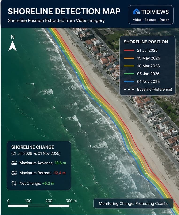
Shoreline detection map
Module A

Shoreline Detection

Uses multi-spectral satellite imagery and local video feeds to detect shorelines, monitor retreat rates, and map beach morphology at high frequencies.

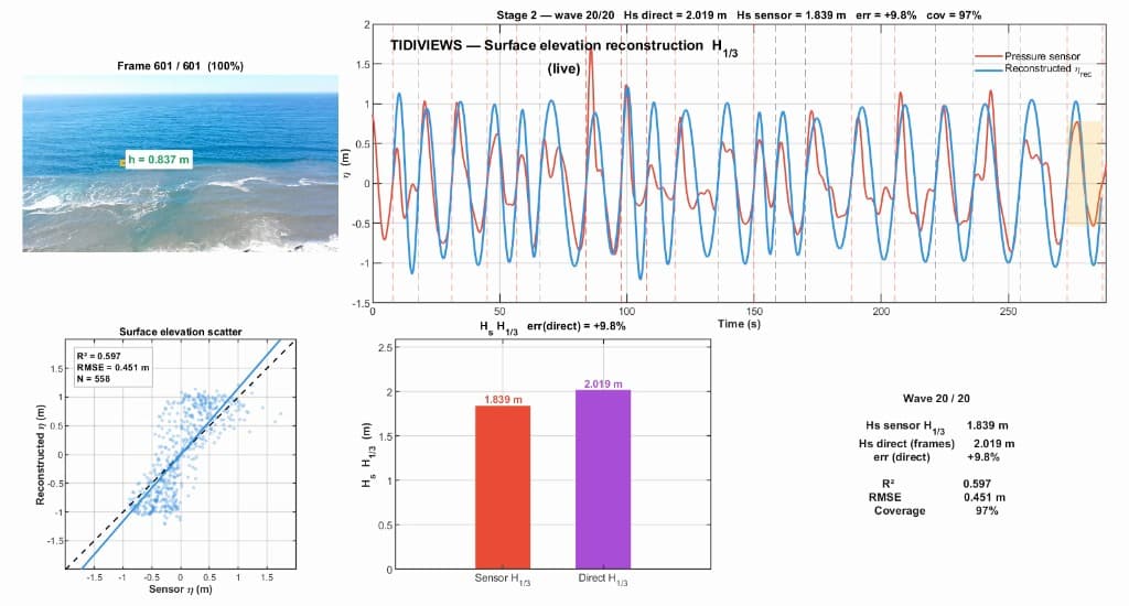
TidiViews wave analytics showcase
Module B

⁠Precision Coastal Observation & Analytic

Converts video observations (from mobile or fixed cameras) into nearshore wave parameters (Significant Wave Height, Wave Period, direction) and local tide monitoring without in-situ buoys.

Nearshore bathymetry analysis
Module C

Wave Overtopping Detection

Analyzes seawall and port infrastructure video feeds to identify active wave overtopping, measure splash frequency, and forecast localized flood hazards.

REGIONAL ADAPTABILITY

One global model does not fit every coastline

Generic global wave and hydrodynamic models lack the resolution needed for local engineering decisions. Coastal processes vary significantly across geography: European shorelines experience high tidal ranges and severe storm swell, whereas West African coastlines exhibit unique long-period waves, different sediment transport dynamics, and severe erosion patterns.

Our system is designed around regional adaptation. We train and calibrate our models using local observations, ensuring that our outputs match the hydrodynamic reality of your specific coastline.

THE PIPELINE

How our platform delivers insights

Stage 011

Multi-Sensor Capture

Ingest video streams, drone imagery, satellite data, and localized metadata from the field.

Stage 022

Signal Processing

Apply computer vision, image stabilization, and frame-level filtering to isolate hydrodynamic signatures.

Stage 033

Regional Calibration

Validate inputs against localized physics-based models to account for bathymetry and tide ranges.

Stage 044

Decision Support Outputs

Generate structured, confidence-scored reports (Significant Wave Height, Wave Period, depth, shoreline position) via secure APIs or web interface.

CONTACT US

Connect with our coastal engineering team

To schedule a custom demo or explore a pilot deployment:

CITIZEN SCIENCE & DATA COLLECTION

Coastal data collection program

Contribute wave observations and video streams from your coastline to help calibrate regional models.

Join as a Data Collector